How to track real-time air quality with Google Maps as pollution spikes across India
Google Maps assigns a numerical value to air quality on a scale from 0 to 500, updated every hour.
ADVERTISEMENT
As winter sets in across India, pollution levels have once again surged sharply, with the national capital bearing the brunt. On Tuesday, at around 9 a.m., Delhi recorded an Air Quality Index (AQI) of 435, according to data from aqi.in—placing the city firmly in the “severe” category.
Real-Time AQI for Everyday Decisions
The AQI layer is available on both the mobile and desktop versions of Google Maps. It uses a clear, colour-coded display to reflect pollution levels—ranging from green for clean air to dark red for hazardous conditions. This guidance helps users decide whether they should exercise outside, tweak their commute, or take safety measures such as wearing a mask.Google previously displayed air quality data with noticeable delays, but the updated feature now offers hourly refreshes. It spans more than 40 countries, enabling users to check conditions not only in Indian cities but also in global locations such as Beijing and New York.
How Google Maps Displays Air Quality
Google Maps assigns a numerical value to air quality on a scale from 0 to 500, updated every hour. Lower values indicate cleaner air, while higher readings reflect worsening conditions. The classifications are as follows:
0 to 50: Good (green)
51 to 100: Satisfactory (yellow)
101 to 200: Moderate (orange)
201 to 300: Poor (red)
301 to 400: Very Poor (purple)
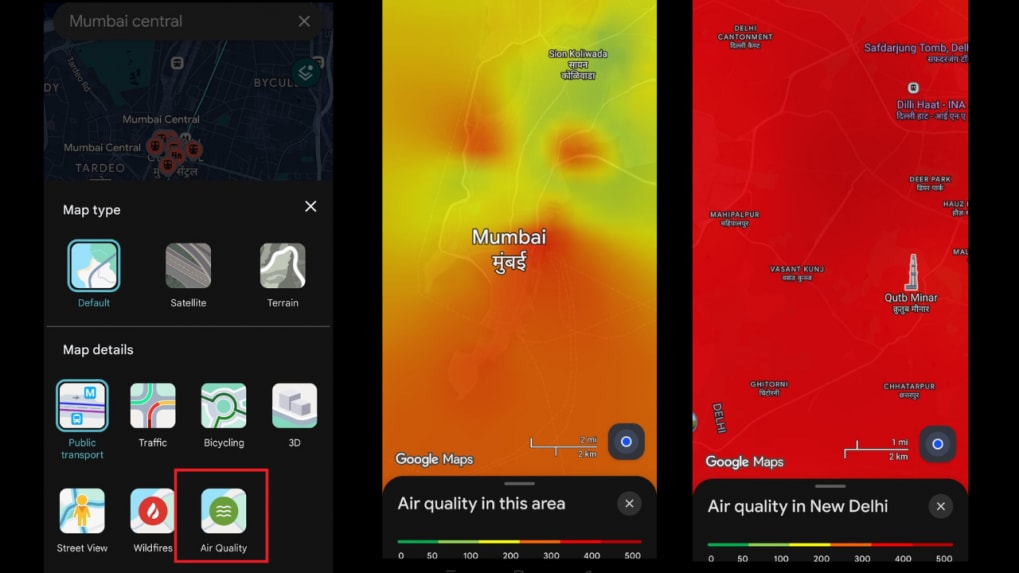
How to Check AQI on Google Maps: Step-by-Step
Update the app: Ensure you’re using the latest version of Google Maps on your Android or iOS device.Search for a location: Enter the name of a city, region or landmark in the search bar, or zoom in to view air quality around your current location.
Open the layers menu: Tap the layers icon—displayed as a stack of squares—next to the search box.
Select “Air Quality”: Choose the “Air Quality” option from the list. The AQI levels for the selected area and nearby regions will appear instantly.
View detailed readings: Tap any shaded area or marker to access the AQI score, pollutant details and associated health advisories.


